Showing posts with label Travel. Show all posts
Showing posts with label Travel. Show all posts
Tuesday, July 24, 2012
Biking Across Snoqualmie Pass?
This post was contributed by Scott Chilberg.
Biking across the Cascades just ain’t what it used to be, thanks to I-90 construction along Keechelus Lake and a series of tunnel closures on the John Wayne Pioneer Trail between Thorp and South Cle Elum. Luckily, alternate east-west routes allow for continued bicycle access through these areas, so if you’re planning a bike trip make sure to read up on the closures prior to heading out and look out for bicycle route signs along the way. Here’s the low-down on the detours:
Due to construction of the I-90 Snoqualmie Pass East Project, WSDOT is restricting interstate bicycle access between Exit 54 and Exit 62. The suggested detour runs along the west side of the Keechelus Lake on the John Wayne Pioneer Trail. According to the WSDOT website, this 8-mile trail loops around the lake for about an hour before reconnecting with the freeway and is not recommended for racing-style bikes due to the occasional loose gravel spots and potholes. Bicyclist may also use US 12 White Pass or US 2 Stevens Pass to cross the Cascades. A map of the detour and more information regarding trail conditions and the construction project can be found here.
Four tunnels along the John Wayne Pioneer Trail between Thorp and Cle Elum will also be closed for an indefinite period because of safety concerns. Detours for both eastbound and westbound travelers are marked along the route, so cyclists should look out for yellow signs and maps marking alternate routes. Visit the Washington State Parks website for detailed directions and more information about the tunnel closures.
As long as you’re aware of the detours, biking along this stretch will remain very doable, so don’t be discouraged! Just make sure you’re on the alert for detour signs and, as always, do your research before embarking on your trip.


Monday, June 4, 2012
Biking in Bend
 |
| Mirror Pond. |
Bend is a magnet for outdoor enthusiasts. This central Oregon community sits in the shadows of Mount Bachelor and The Sisters on a high desert plateau. The region offers opportunities for skiing, snowshoeing, desert and mountain hiking, kayaking, and lots of mountain and road biking.
What impressed
me, tho, was the level of everyday biking I observed in town. I saw lots of folks on bikes! I saw residents biking to work and kids
biking to school. I saw shoppers
carrying their goods in baskets. I saw
college students on bikes. I watched
kids arrive at the library and community center on bikes. I saw patrons arriving and departing on bikes
at brew pubs.
 |
| A typical Bend bicyclist. |
Overall, we felt welcomed as a bicyclists. Bike parking was everywhere. Bike racks are easy to find in downtown Bend and they have a bike corral. We found bike parking at the library, parks, pubs and shopping centers. We saw a number of artistic bike racks too.
 |
| The bike corral gets plenty of use. |
 |
| One of the many decorative bike racks in Bend. |
 |
| The Cyclepub cruises through downtown Bend. |
 |
| Grade-separated bike lane in Bend. |
The one thing that we missed as a bicyclists was a local bike map. As visitors, we really could have benefited from a bike map showing us where bike lanes and trails were located and offering some suggested routes.
Monday, April 23, 2012
Off the Freeway

I work at a bicycle advocacy organization. Among my tasks is
answering telephone and email questions about bicycling in general and
frequently those are about possible routes.
Today I got a request from a father in Bellingham who had a wonderful idea as a parent. His son graduated from high school last month and is heading off to college next month. As a way of symbolizing the rite of passage, and a (possibly last) chance to spend some time together, they decided to bicycle together to Washington State University in Pullman. I thought it was a great idea. (He seemed to need my encouragement.)
Neither are serious bicyclists, but they've been enjoying riding together the last year or so and decided to take on this very big undertaking (It's 400 miles or more). His reason for calling was a routing question. He said,
Today I got a request from a father in Bellingham who had a wonderful idea as a parent. His son graduated from high school last month and is heading off to college next month. As a way of symbolizing the rite of passage, and a (possibly last) chance to spend some time together, they decided to bicycle together to Washington State University in Pullman. I thought it was a great idea. (He seemed to need my encouragement.)
Neither are serious bicyclists, but they've been enjoying riding together the last year or so and decided to take on this very big undertaking (It's 400 miles or more). His reason for calling was a routing question. He said,
"I know we go down Interstate 5 100 miles to Seattle,
get on Interstate 90 and go east a couple hundred miles, but I don't know where
to go once I get out towards Spokane. Can you tell me what turn to take?”
There was a long, long pause as I gathered my thoughts and
prepared for a nasty conflict.
The route he was suggesting, 5 to 8 days of really miserable riding on Interstate freeways, was awful. This is not that unusual. Many people forget to stop thinking like a car when they get on a bike. Still, I was shocked... and nervous. I had a good suggestion for that last day of riding, (there is also a major highway similar to his suggestions) but I also had a half-dozen much better routes to suggest for the first week.
I took a deep breath and started in... Stevens Pass, North Cascades Highway, White Pass, Chuckanut Drive, The Skagit Valley, The Centennial Trail, back roads, country roads, bike trails, away from the highways. Quiet roads.
I finished my monologue and prepared for the response. People get very defensive about routes and it's a strangely common reaction to be pretty angry at the suggestion of quieter routes.
I was met with silence. A long silence. A concerning silence. I wasn't even sure he was still there.
Finally he said,
The route he was suggesting, 5 to 8 days of really miserable riding on Interstate freeways, was awful. This is not that unusual. Many people forget to stop thinking like a car when they get on a bike. Still, I was shocked... and nervous. I had a good suggestion for that last day of riding, (there is also a major highway similar to his suggestions) but I also had a half-dozen much better routes to suggest for the first week.
I took a deep breath and started in... Stevens Pass, North Cascades Highway, White Pass, Chuckanut Drive, The Skagit Valley, The Centennial Trail, back roads, country roads, bike trails, away from the highways. Quiet roads.
I finished my monologue and prepared for the response. People get very defensive about routes and it's a strangely common reaction to be pretty angry at the suggestion of quieter routes.
I was met with silence. A long silence. A concerning silence. I wasn't even sure he was still there.
Finally he said,
"I'm really embarrassed, I've lived here my whole life
and it never occurred to me that there was any other way to get to Seattle
except on I-5... of course it would be nicer to ride on some of those other
roads."
And why don't more people bike?
I've had the same experience in Seattle with new or prospective cyclists asking me about routes around town, assuming that the ONLY option was the nasty, clogged, smelly, loud, intense, motor filled arterial. Forgetting that the quiet streets, the neighborhoods, the pleasant and interesting streets even exist. Missing the point.
Cyclists need to stop thinking like cars. Actually I think everyone: city planners, drivers, developers, pedestrians, EVERYONE needs to stop thinking like cars, but it's amazing how often I see cyclists stuck in that car-think.
Wednesday, November 30, 2011
Confessions of a Maphead

I love maps. Nothing launches me into scheming and daydreaming for an adventure like a good map. Maps reveal interesting routes to destinations near and far. They help me plan a bike tour through Canada’s Gulf Islands, plot a backpacking route into Eagle Cap Wilderness, and navigate my way to a mountain onsen in Japan.
Maps are my friends and I am blessed to have an abundance of them. In fact, I confess that I have a dresser drawer full of maps. I have maps that accompany me on urban bike commutes, bike tours, mountain bike rides, snowshoe outings, day hikes, wilderness backpacking trips, ski tours on trails and into untracked terrain, and road trips.
The map is my co-pilot. It suggests route possibilities, warns me of potential obstacles, and guides me through unfamiliar territory. Maps take a licking and keep on ticking—or something like that. I have spilled beverages on maps, dropped them on muddy trails, used them as notepads, and refolded them all sorts of ways. They continue to serve their purpose in spite of the abuse.
Maps—don’t leave home without one. In fact, carry several. I usually stash an extra Seattle bike map or two with me on my commute to hand out to the lost or confused cyclist I occasionally encounter along the way. It’s a not-so-random act of kindness and a way to spread the map love.
“Thanks!” exclaims the grateful cyclist. “I didn’t know Seattle had a bike map.”
Seattle does indeed have a bike map. So does Vancouver, Spokane, and a host of other communities. There’s even a Washington State bike map. Check the maps section of our website for some links.
I’ve been known to select a destination because I saw it on a map. I hiked to Indian Henry’s Hunting Ground and the Plain of Six Glaciers simply because I was attracted to their names on a map. I camped at Kodachrome Basin State Park because, with a name like that, it had to be scenic (I wasn’t disappointed). I biked the Columbia River Gorge because it looked like an interesting route on a map.
Maps can’t tell you everything, but they can reveal enough information to get you scheming on an adventure in your neighborhood or someplace far away. Where has a map led you?
Tuesday, September 27, 2011
Bike Maps

Are you ready to try biking to work or school but you're unsure of a decent route? Are you interested in finding new bike trails to explore? Maybe you want to explore a particular part of the state by bike but you're not familiar with the area.
There's a good chance that there's a bike map out there that can assist you with planning your routes and adventures. Many of our cities and counties have produced bike maps that show routes commonly used by bicyclists. They can help you find low-traffic streets, streets with bike lanes or shoulders, and local bike trails. There's even a state bike map produced by WSDOT.
Do you live in Vancouver and work in Portland? You're in luck! The City of Vancouver has a bike map that includes bike routes in Portland. You can request a hard copy of the bike map or view it online. Check here for details.
Maybe you're a freshman at Western Washington University and you brought your bike to campus but you're not familiar with Bellingham area. No worries. Just get your hands on the Bellingham and Whatcom County bike maps.
Are you itching to explore the John WayneTrail or the Olympic Discovery Trail? Maybe you'd like to spend time touring the Columbia River Gorge or the Walla Walla wine country. There are maps to assist you with route finding.
A section of the Bicycle Alliance website is dedicated to bike maps. You’ll find links to many bike and trail maps, most of which can be viewed and downloaded. You’ll also find links to sites that allow users to post their favorite bike rides and map their own routes. Check it out!
Wednesday, June 22, 2011
US Bike Route 10: The Work Begins
In May, the Bicycle Alliance participated in a month-long fundraising campaign organized by Adventure Cycling Association for the US Bicycle Route System (see this post). The campaign raised over $31,000 nationally and we raised close to $1000 of that. Thanks again to all of you who made a contribution!
For those not familiar with the USBRS, picture an interstate travel system designed with bikes in mind. These routes will be officially recognized, mapped and signed. Using the road less traveled, it will connect communities, parks, landmarks and other popular destinations while traveling through some of the best scenery America has to offer. Adventure Cycling is leading this ambitious effort nationally and the Bicycle Alliance has stepped up to lead the effort in our state.
 Now we're rolling up our sleeves and getting down to business. As the lead partner in the USBRS effort in Washington State, we're hitting the road to meet with elected officials, transportation staff, and community advocates along the northern tier corridor that will someday become US Bicycle Route 10.
Ian Macek, WSDOT's Bicycle Pedestrian Coordinator, will join us as we hold outreach meetings along the corridor to begin the planning and implementation of USBR 10. We're holding our first meeting this week in Twisp. The Methow Valley offers some great biking and folks over there know the economic benefit of bicycle tourism.
If you live along the USBR 10 corridor and would like to help champion the project in your community, please email me at louisemc@bicyclealliance.org. We'd especially like to hear from if you live in the eastern half of the state.
For those not familiar with the USBRS, picture an interstate travel system designed with bikes in mind. These routes will be officially recognized, mapped and signed. Using the road less traveled, it will connect communities, parks, landmarks and other popular destinations while traveling through some of the best scenery America has to offer. Adventure Cycling is leading this ambitious effort nationally and the Bicycle Alliance has stepped up to lead the effort in our state.
 Now we're rolling up our sleeves and getting down to business. As the lead partner in the USBRS effort in Washington State, we're hitting the road to meet with elected officials, transportation staff, and community advocates along the northern tier corridor that will someday become US Bicycle Route 10.
Ian Macek, WSDOT's Bicycle Pedestrian Coordinator, will join us as we hold outreach meetings along the corridor to begin the planning and implementation of USBR 10. We're holding our first meeting this week in Twisp. The Methow Valley offers some great biking and folks over there know the economic benefit of bicycle tourism.
If you live along the USBR 10 corridor and would like to help champion the project in your community, please email me at louisemc@bicyclealliance.org. We'd especially like to hear from if you live in the eastern half of the state.
Tuesday, May 24, 2011
USBRS: Never Alone
Today's blog post was written by Seattle bicyclist Kevin Henderson. He shares a reason why the US Bicycle Route System (USBRS) is important to him.

In the summer of 2009, I embarked on my first long distance bike tour, alone. This had been something I'd dreamed of since I was a teenager in the 70s, and one day something finally clicked in me that said "you need to do this, this is the year."
My destination, Scottsbluff, Nebraska, made sense to me, since I was born there and have great childhood memories of many visits with my extended family during visits over summer vacations. The only problem was, how do I get there? What's a good route? Browsing the internet, I was lucky to find blogs of some others who had traveled along routes that I could make use of, at least in part, to get where I was going. Bike travel has some different considerations than motorized travel. For example, it's good to plan your travel time to be off the road by the time the hottest summer sun is beating down. In order to make the day's travel segment work out, it really helps to be able to predict what lies ahead.
I pieced my route together with combinations of local city and state bike maps, and with the help of selections from Adventure Cycling's library of route maps. I was happy to find that I could make use of portions of both the Lewis and Clark and TransAmerica routes.
In retrospect, I have to say that traveling on a route planned for and by cyclists makes a world of difference. In a sense, though I was making this trip by myself, being on an Adventure Cycling route helped me feel like I was never really alone. The things you care about when you're on a bike like "where's the next available water, or restroom, lodging, or even, how much further will this uphill last" are all readily apparent.
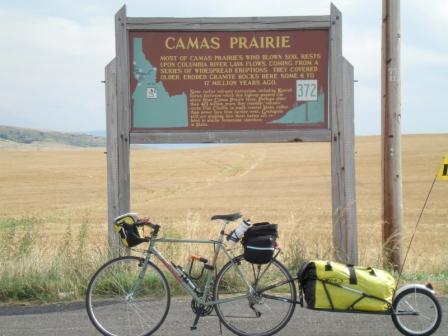
By virtue of the work of all the people that went into making the route, I felt connected to those who came before me. In the best way, I was never really alone. The concept of a U.S. Bicycle Route System appeals to me, because it shouldn't take planning on the order of a lunar expedition to get out and see our country in the best possible way: on a bike!
Building the USBRS is an ambitious undertaking and the Bicycle Alliance is working with Adventure Cycling to create USBRS routes in Washington State. A fundraising campaign for the USBRS is underway during the month of May. A donation (as little as $10) through our Team Washington page ensures that a portion of your contribution will be dedicated to efforts in our state.
Thursday, May 19, 2011
USBRS: A Tale from the Road
Today's guest blogger is Phyllis Counts of Seattle, who is sharing a tale from her cross-country bike trek in 2010. Phyllis is supportive of the US Bicycle Route System and our efforts to create routes in Washington State. We hope you'll support our effort as well with a $10 donation to our USBRS Team Washington fundraising page.
Fred and Barb.
Just two examples of why this U.S. bicycle route system is a good idea. And they're not even from here … Egads, they're FOREIGNERS!
Just two examples of why this U.S. bicycle route system is a good idea. And they're not even from here … Egads, they're FOREIGNERS!
Last summer when I was pedaling across the country with my friend Jerry, we had the pleasure of meeting these two colorful, happy, and vigorous souls … a 77-year-old couple from Melbourne, Australia. Fred and Barb are retired sheep ranchers, who, until around the time they both turned 70 and hopped on their first touring bikes, were simply hard working Aussies, raising kids and grandkids and keeping their ranch running. When Fred retired from sheep ranching, he became a contractor, building and remodeling homes. Barb retired from her university position as an accounting professor.
Somewhere around that time, they were given a tandem, started bicycle touring, and haven’t looked back. They have toured in Tasmania, Australia, New Zealand, Europe, Canada and completed two tours in the United States, the first using the Adventure Cycling Pacific Coast route, and then fulfilled their long time dream of riding across the country, coast to coast on the classic TransAmerica route.
 |
| Fred and Barb touring Yellowstone National Park. |
It was our good fortune and sheer delight to meet and travel with them for weeks while they pushed and pulled their fully loaded Co-Motion tandem through the Appalachians, the Ozarks, the Rockies and finally the Cascades. They infused our days and nights with great humor and Aussie insights, delighting in sights, sounds and historical monuments that we mostly take for granted.
Barb and Fred are only two of the many amazing adventure cyclists we met coming across from Virginia to Oregon.
My point to this reminiscing is that our trip and our lives were enriched by meeting and traveling with these people, folks we most likely would not have met had it not been for the detailed route and map system established by Adventure Cycling Association that we were all following. If we had all been on different highways and backroads, we might never have bumped into each other.
In our cross country bicycle journey, having common routes made the difference — whether it was to borrow a pump or spare tube in a crashing rainstorm, soaking up companionship and stories after a climbing three or four mountain passes in one day, or getting into a pickup game of tent-sack football in a small city park — it made the entire trip a richer experience.
 |
| Fred and Barb on their Co-Motion tandem in the high plains of Colorado. |
To Fred and Barb we say thanks for being our new friends, and for the invitation to come do a little bicycle touring in Australia. And, thanks to Adventure Cycling Association for mapping fabulous routes and continuing to be a great cycling resource, and source of inspiration to travel by bike.
Adventure Cycling is leading the national effort to create the US Bicycle Route System and the Bicycle Alliance is their partner in Washington. A USBRS fundraising campaign is happening during the month of May. If you make a contribution through our Team Washington page, a portion of it will be dedicated to the work here in our state.
Tuesday, May 10, 2011
USBRS: You can double your donation this week!

May is Bike Month, so what better time to raise money for the US Bicycle Route System (USBRS)! AdventureCycling Association, the lead to create the USBRS, is running a fundraising campaign this month for the USBRS and the Bicycle Alliance of Washington is participating as Team Washington.
What is the USBRS? Imagine an interstate highway system for bikes…mapped, signed and officially recognized network of routes crisscrossing our country and created with the bike traveler in mind. This network of bike routes would connect urban centers, parks, landmarks and other popular destinations, and travel through some of the best scenery that America has to offer.
Why is the Bicycle Alliance involved? We have partnered with Adventure Cycling to create the planned bike routes for Washington State. We’re already working with Washington State Dept of Transportation (WSDOT) on USBRS Route 10, the northern route across our state. If you make a donation to the USBRS campaign through our Team WA fundraising page, a portion of the money raised (20%) will be dedicated to the USBRS efforts in our state.
And thanks to AdventureCORPS, you can double your donation if you make it this week! AdventureCORPS is offering to match $1000 in donations made this week. This is a great week to give to the campaign and double your support of the USBRS.
Please make your donation today. Just go to our Team WA fundraising page and make a contribution to the USBRS. You can donate as little as $10 to qualify for the match from AdventureCORPS.
Build it. Bike it. Be a Part of It.
Thursday, May 5, 2011
USBRS: Check out the Map
The Bicycle Alliance has stepped up to work with Washington State Department of Transportation to develop the USBRS bike routes in our state. We are currently working on USBRS Route 10, the northern route that will connect to Alaska (via the ferry) to the west and Idaho to east. Check out the USBRS National Corridor Map to get a feel for the national plan. You can see that six bike route corridors are planned to travel through Washington State.
Please make a donation to the USBRS effort through our Team Washington page. Twenty percent of the funds raised through our team page will be dedicated to the USBRS efforts in Washington State.
Build it. Bike it. Be a part of it.
Monday, May 2, 2011
Help us make the US Bicycle Route System a reality in Washington State

Imagine an interstate highway system for bicycles…officially recognized and signed bike routes that crisscross our country. This network of bike routes would connect urban centers, parks, landmarks and other popular destinations, and travel through some of the best scenery that America has to offer.
This is no pipe dream. I’m talking about the US Bicycle Route System (USBRS), an ambitious project led by the Adventure Cycling Association. Two official routes are already on the ground and more are on the drawing board.
The Bicycle Alliance of Washington is partnering with Adventure Cycling to create the routes in our state that will be part of the USBRS. Washington State Department of Transportation (WSDOT) is working with us on this effort and we hope to have our first officially recognized US bike route in a few years.
Adventure Cycling is doing a fundraising campaign for the USBRS during the month of May. We are participating as Team Washington and we hope you will make a donation to our team. Twenty percent of the money that we raise as Team Washington will come back to support the local effort.
Use this link to our fundraising page to make a contribution to the USBRS and Team Washington today. Everyone who makes a donation to our team will be eligible for a drawing for some cool gifts, including a Share the Road jersey.
Build it. Bike it. Be a part of it.
Subscribe to:
Posts (Atom)